TRAILS
Before Visiting a Trail or Park, follow these links to read about current conditions and etiquette.
Massillon Area Green Ways, Inc. consists primarily of three trails: Congressman Ralph Regula Towpath Trail, Sippo Valley Trail, which are both part of the Ohio to Erie Trail, and Olde Muskingum Trail.
Plus, there is bicycling in the City of Massillon where road bicyclists follow “sharrows.”
In cooperation with Stark Parks, the Massillon Recreation Department, and the Ohio to Erie Trail, please find the trail you plan on visiting below and follow the link to their website for current Maps and Trail information.
Congressman Ralph Regula Towpath Trail
Updated Summary from Ernie’s Bicycle Shops website:
You may have noticed recent trail closures along the Towpath Trail in Massillon. Reopening day is just around the corner, but here’s what you need to know in the meantime:
The trail is currently open heading north from Tremont Ave in Massillon, but remains closed between Tremont and Warmington Rd. Unfortunately, no safe detour exists if you wish to continue south from Tremont on the Towpath. But you do have some good alternatives.
1. At Tremont Ave, you can pick up the 11-mile Sippo Valley Trail and head west toward Dalton. (See the connector map.) This is also the route you’ll want to use if you’re riding the Ohio to Erie Trail.
2. Or, to explore the Towpath from Navaree to Zoar, park at John Glenn Grove on Warmington Road and head south from there.
The closures are the result of an ongoing federal project to stabilize the levee along the Tuscarawas River. Built in 1951, the levee protects downtown Massillon from flooding. River eroision has deteriorated the levee in recent years, and federal officials have allocated $22 million for its rehabilitation (and improvements to the Towpath in the process!). The project is expected to be completed in June 2023.
If you need guidance, advice, maps, or encouraging ice cream! You can stop down at Ernie’s Bicycle Shop, just off the Towpath Trail!
If you’d like more information on this and future Towpath closures, please contact:
Stark Parks
512 12th St NW
Canton, OH 44708
330-477-3552
Monday – Friday, 8am-4:30pm
Visit https://www.erniesbikeshop.com/towpath
Summary from Stark Parks website:
- Enjoy 25 miles of the iconic Ohio & Erie Canal Towpath Trail in Stark Parks! Begin your hiking or biking adventure at any one of the 14 trailheads. The shady, flat terrain parallels the Tuscarawas River through deciduous forests and rural and urban landscapes.
- Stop for a picnic at Lock 4, Lake Ave., John Glenn Grove, or Craig Pittman trailheads. Fish at Lake Lucerne, along the canal at Lock 4, at Wooster St., or in the nearby Tuscarawas River.
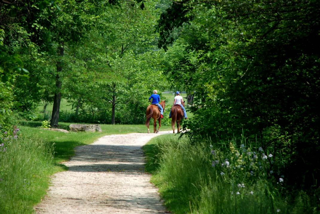
- Ride your horse on the Towpath Trail from the Summit Co. line to Cherry St. then along the parallel Olde Muskingum Trail for 6 miles to Forty Corners. Equestrians are not permitted on the Massillon portion of the trail. Horseback riders may use the Southern Section of the Towpath Trail between John Glenn Grove and the Tuscarawas county line.
- The Towpath Trail and bordering park lands follow the historic route of the Ohio & Erie Canal through what once were three thriving canal villages, now the cities of Canal Fulton and Massillon and the Village of Navarre. This Stark County section is part of the 110-mile Ohio & Erie Canalway National Heritage Area which extends north all the way to Cleveland and south to New Philadelphia.
- In many areas the old canal bed is still visible. In the Canal Fulton area, the canal has been preserved, allowing for rides on a replica canal boat, the St. Helena III, during the spring and summer.
Sippo Valley Trail
Summary from Stark Parks website:
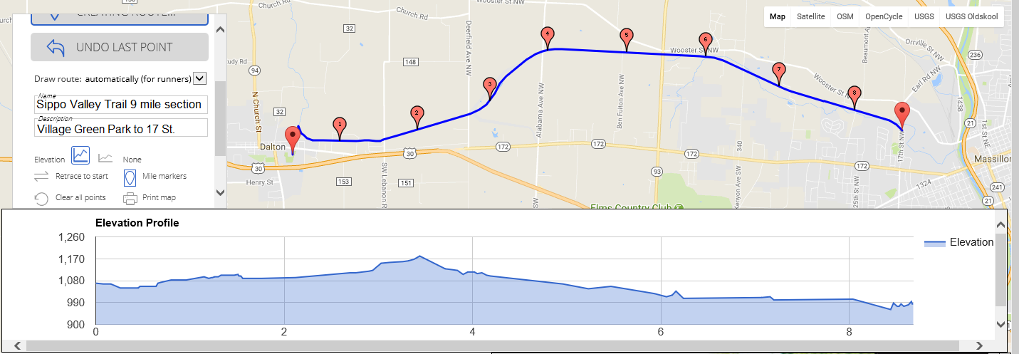
- Bike, hike, walk, or jog nearly over 10 miles between Massillon and Dalton in Wayne County, ending just north of Rt. 30. The Sippo Valley Trail also connects to the Towpath Trail at the west side of Tremont Ave. in Massillon.
- An asphalt trail surface transitions to limestone between Skyland Ave. and Deerfield Ave. The flat, gentle grades parallel Sippo Creek for much of the route.
- Hit the trail with your pet! Just remember that dogs must be leashed at all times, and owners must dispose of pet waste properly.
- Pull-off parking is available at Bison Ave./27th St., Kenyon Ave., and Alabama Ave. A 15-car Trailhead is located at Skyland Ave. Parking lots at Lincoln Park and Bottoms Park are maintained by the City of Massillon and have close access to the trail.
- Equestrian trailer parking is not available. Local users that walk or ride in with horses must use the berm to the side of the trail between Deermont Ave. and Deerfield Ave.
- Toggle left or right on the 2 photos above (on a mobile device) or to the right to see an elevation scale of a 9 mile section of the 10.5 mile Sippo Valley Trail.

Sippo Valley Trail
Summary from Stark Parks website:
- Bike, hike, walk, or jog nearly over 10 miles between Massillon and Dalton in Wayne County, ending just north of Rt. 30. The Sippo Valley Trail also connects to the Towpath Trail at the west side of Tremont Ave. in Massillon.
- An asphalt trail surface transitions to limestone between Skyland Ave. and Deerfield Ave. The flat, gentle grades parallel Sippo Creek for much of the route.
- Hit the trail with your pet! Just remember that dogs must be leashed at all times, and owners must dispose of pet waste properly.
- Pull-off parking is available at Bison Ave./27th St., Kenyon Ave., and Alabama Ave. A 15-car Trailhead is located at Skyland Ave. Parking lots at Lincoln Park and Bottoms Park are maintained by the City of Massillon and have close access to the trail.
- Equestrian trailer parking is not available. Local users that walk or ride in with horses must use the berm to the side of the trail between Deermont Ave. and Deerfield Ave.
- Toggle left or right on the 2 photos above (on a mobile device) or to the right to see an elevation scale of a 9 mile section of the 10.5 mile Sippo Valley Trail.
Olde Muskingum Trail
Summary from Stark Parks website:
- Enjoy hiking and biking on the 5.74-mile limestone surface trail or horseback riding on the wide compacted grass berm with mounting blocks. This scenic route follows along the western edge of the Tuscarawas River near the Ohio & Erie Canal and parallels an active railroad from Canal Fulton to Jackson Township.
- Parking, including space for horse trailers, is available on Cherry St. in Canal Fulton and at Butterbridge Rd. The Forty Corners Trailhead on the Towpath Trail can also be used for general parking.
- Dogs welcome! Just remember that dogs must be leashed at all times, and owners must dispose of pet waste properly.”
Ohio to Erie Trail
A primarily off-street recreational trail from the Ohio River to Lake Erie, the Ohio to Erie Trail spans the state of Ohio from Cincinnati to Cleveland for the most part following lands formerly occupied by railroads and canals. The collection of regional trails connects four of Ohio’s metropolitan cities, a dozen large towns and numerous small villages – all done on easily accessible, paved trails that are primarily separated from highways and automobiles. The length in 2017 is 326 miles.
What You’ll See
Along the way, the trail passes through rural areas, farmlands, nature preserves, and regional parks giving the adventurous a hearty helping of nature’s finest. The small rural towns are a treasure of small shops, restaurants and history of Ohio. At the metropolitan perimeters, meadows and woods give way to exciting urban centers, affording the traveler a contemporary taste of Ohio’s culture and arts.
Everyone Welcome
The Ohio to Erie Trail is a collection of multi-use trails that provide exercise and adventure to anyone who’s willing to leave the automobile behind. Bicyclists, equestrians, skaters, hikers, families with strollers, bird watchers, walkers and nature lovers are a common sight. In the winter, the trail becomes a snowshoe and cross-country ski path. And, for those with mobility impairments, construction designs call for full compliance with ADA guidelines so that everyone has the opportunity to explore the natural beauty of Ohio as the trail weaves its way across the state.
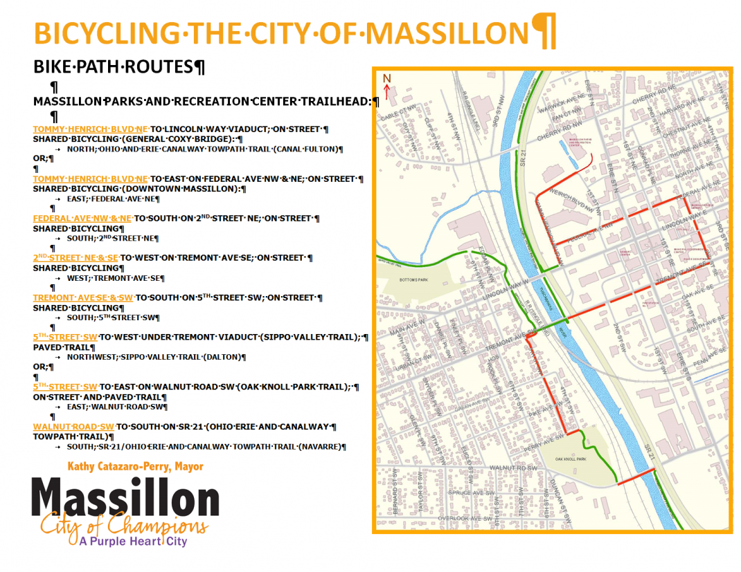
Bicycling in the City of Massillon
To view map on the right at full size, right click image, then click on “view image”.
Click your browser’s back button to return to this webpage.
Simply zoom in on your mobile phone.
Bicycling in the City of Massillon
To view map on the right at full size, right click image, then click on “view image”.
Click your browser’s back button to return to this webpage.
Simply zoom in on your mobile phone.